Military Tower
Military Tower
Military airfields operate differently from the civilian airports most pilots are familiar with. While they also have a control tower and a radar unit comparable to an approach controller, the vertical extent of the radar-controlled airspace is significantly lower than in civilian operations. Before addressing radar services in more detail, this section focuses on the responsibilities of the Tower position.
Reference Documentation
Charts and airspace information for German, English and many more military airfields can be found in the Mil AIP at www.milais.org/
Weather Information
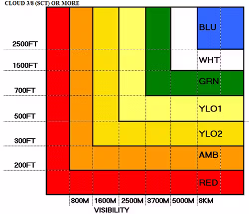
Airfield Color States
Unlike civilian control towers, military towers do not provide an ATIS. Instead, weather conditions are communicated using a standardized color code system. In addition to the color state, pilots must be informed of the current QNH and the runway in use.
The color codes and their corresponding weather minima are listed below. If the reported visibility and cloud ceiling would result in different color states, the color representing the more restrictive conditions is applied.
-
BLU+: Cloud ceiling below 20,000 ft with more than half of the sky covered (excluding BKN or OVC below 20,000 ft)
-
BLU: Visibility at least 8,000 m, cloud ceiling at or above 2,500 ft
-
WHT: Visibility at least 5,000 m, cloud ceiling at or above 1,500 ft
-
GRN: Visibility at least 3,700 m, cloud ceiling at or above 700 ft
-
YLO1: Visibility at least 1,600 m, cloud ceiling at or above 500 ft
-
YLO2: Visibility at least 1,600 m, cloud ceiling at or above 1,600 ft
-
AMB: Visibility at least 800 m, cloud ceiling at or above 800 ft
-
RED: Visibility below 800 m, cloud ceiling below 200 ft, or vertical visibility unknown (VV//)
-
BLACK: Runway closed for reasons other than weather
The White color state is still considered sufficient for VMC operations, where as Green conditions require IFR procedures.
An example may sound:
| ETNN_TWR | PACK21 Nörvenich Tower moin QNH 1001, Active Runway 22, colorcode BLU+ |
In civilian aviation, aircraft usually fly a standart traffic pattern, which is a faily large, rectangular circuit around the airfield. This gives everyone time to see each other and keeps arrivals and departures slow and orderly. In military aviation, pilots often fly what is called a "closed" pattern instead. A closed is a much tighter and faster pattern, flown close to the airfield. After takeoff, the aircraft climbs and turns aggressively, stays near to the runway, and quickly positions itself back onto the final approach. Compared to a civvilian traffic pattern, everything happens in less time and at higher speed. This is common in military flying because it better fits high-performance aircraft and operational training. It saves time, keeps the aircraft close to the field, and trains pilots to fly precise visual patterns similar to how they would operate in real missions.
An example for an VFR Military aircraft flying in an closed will sound something like this from the beginning to the end:
| PACK21 | Nörvenich Tower, PACK21 |
| ETNN_TWR |
PACK21, Nörvenich Tower |
| PACK21 | PACK21 request taxi. |
| ETNN_TWR | PACK21 QNH 1001, Active Runway 24, colorcode BLU+. Taxi Last chance East via the southern crossing active is approved. |
| PACK21 | QNH 1001, Active Runway 24, colorcode BLU+. Taxing Last chance East via the southern crossing active approved PACK21. |
| PACK21 | PACK21 Holding point Runway 24 ready for departure request right closed. |
| ETNN_TWR | PACK21 winds 240° 4 knots runway 24 cleared for Takeoff, Right closed approved. |
| PACK21 | Runway 24 cleared for takeoff right closed approved PACK21. |
| PACK21 | PACK21 Right base Runway 24 gear down and locked full stop. |
| ETNN_TWR | PACK21 winds 240° 4 knots runway 24 cleared to land. (Vacate runway to the Left) |
| PACK21 | Cleared to land runway 24 PACK21 |
| PACK21 | Safe rolling PACK21. |
| ETNN_TWR | PACK21 Taxi Box 8 via the southern. |
| PACK21 | Taxing Box 8 via the southern PACK21. |
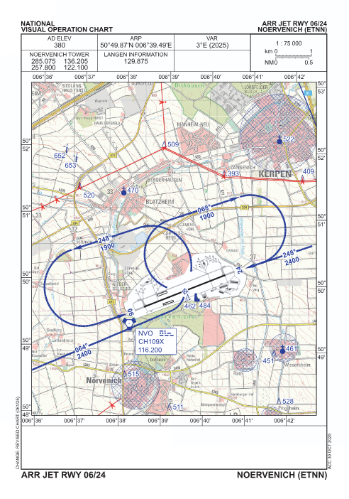
An closed pattern on the charts may look something like this: